DM4DEM: A GRASS-compatible
tool for blunder detection of DEM
Gonzalo Durañona
(gonzalod@interware.org) and Carlos López (carlos.lopez@ieee.org) (*)
Centro de Cálculo,
Facultad de Ingeniería
Montevideo, URUGUAY
Present day GIS are complex pieces
of software devoted to manipulate, analyze, store and report results about
geographic data. However, there is a substantial lack of standard, readily
available tools to critically analyze the input data itself, in order to
detect or highlight suspicious values. This complain about present day
software is highly complementary with the one raised about uncertainty
of data, but is not the same. We here attempt to (see references) improve
the accuracy of the dataset by using judiciously the supplied algorithms,
which might help in reducing the uncertainty to some extent. DM4DEM (which
stands for Data Mining for Digital Elevation Models) is an application
for Graphical Information System which can do quality control of raster
data in general, and in particular of DEM. Its interface allows the user
to locate unlikely values of the elevation of the digital set using different
criteria or algorithms even provided by the end user, and later edit them
within the same environment.
The blunder (or oultlier) detection
algorithms shipped with the software does not assume any particular source
for the DEM (i.e. contour lines, photogrammetric pairs, direct survey,
etc.) which makes it very suitable for end users, which might receive the
data just as is without metadata about its lineage.
The usefulness of the software is
illustrated with some example data taken from the literature. To the author´s
knowledge, this is the first implementation of this feature in a popular
GIS package.
The software has the following functions:
-
Find suspect points with advanced algorithms included in the program,
currently those reported by Felicísimo, 1994 and López, 1997,
2000.
-
It is easily extensible. It has the flexibility to allow new algorithms
to be incorporated to the menu.
-
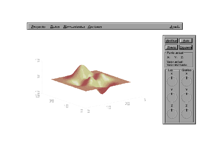
Show 3D views around these points, with rotations, azimuth, and distances
of view appropriately driven by sliders and buttons.
-
Suggests appropriate values for the suspected elevations, with parameters
that can be modified by the user.
-
Supports multiple languages, with spanish and english already available.
-
Has revision facilities, can show history of modified points and
labels of maps.
-
Works where GRASS works, this means, the entire UNIX platform, but
not limited to it.
This product was created to
be executed either from the GRASS shell or the TclTk-Grass bar. Making
use of graphical interfaces, the DM4DEM system follows the same styles
of the applications TclTkGrass, so the user can work on a familiar environment.
Moreover, using the GRASS philosophy,
the system follows the same programming styles that allow the product to
be used cross-platform. It can be installed on different architectures,
giving it more portability for his massive distribution. His development
was done almost all by Linux, and was tested on an AIX Unix system. The
system allows keeping information of the different projects the user works
on, integrated with Grass tools, for the visualization, storage and manipulation
of results from the algorithms.
There is also the possibility of
modify the elevations by automatic algorithms (already supplied or not)
or by manual estimation.
The product will be available on
the WEB soon, both in source and compiled form for the abovementioned operating
systems.
Keywords: blunders, DEM, outliers,
automatic detection, accuracy improvement, GIS, GRASS
Selected references:
López, C., 1997. Locating
some types of random errors in Digital Terrain Models. International
Journal of Geographic
Information Science, 11, 7, 677-698.
López, C. 2000. On the improving
of elevation accuracy of Digital Elevation Models: a comparison of some
error detection
procedures To appear in Transaction on GIS, 4,1.
Felicísimo, A., 1994, Parametric
statistical method for error detection in digital elevation models. ISPRS
J. of Photogrammetry
and Remote Sensing, 49, 4, 29-33.
(*) To whom correspondence should
be directed
Presented at:
4th International Symposium on Spatial Accuracy Assessment in Natural Resources
and Environmental Sciences
July 12-14, 2000
De Rode Hoed, Amsterdam, The Netherlands
Full size paper for download!